
|
In case you missed it ... the City of Thousand Oaks is updating its General Plan. You're wondering why you should care. Another city thing, another thing you don't have time for, right? What is the General Plan, you ask? "The General Plan is the planning and policy document that guides development, enhancement, and conservation in Thousand Oaks. Its purpose is to establish the community’s vision for how it will evolve in the years to come and to put tools in place to implement that vision. The General Plan lays out specific goals and policies that set the stage for future social, economic, and physical development of the City in support of the vision. As such, the General Plan is often referred to as the “blueprint” for the future of the community. California law requires every city and county to adopt a General Plan." Part of that process includes LAND PLANNING, and that's what I want to talk about today. Queue the NIMBYs! Queue everyone that says they're "slow growth" because they know it sounds more reasonable than "no growth," which is what many of them truly are at heart. Folks, we HAVE to increase more housing. And not just housing, affordable housing. And, not just housing, but desirable places to live ... desirable places for businesses to choose to set roots in our economy. Not only is that my opinion, but ... the State mandates it so (or at least mandates that land be designated to support more housing ... after all, a city doesn't pitch to developers ... developers pitch to the city): The recent RHNA (Regional Housing Needs Assessment) allocation for the City of Thousand Oaks calls for the citing of roughly 2,600 additional housing units. This RHNA cycle runs from 2021 to 2029 and requires that these units be sited within the Housing Element of our General Plan, which is currently under review. There is no requirement this number of units be built, but the law requires the land be designated to allow for a minimum of this number, encompassing all housing levels. And so, to this end ... the city began a robust outreach effort using consultants to draw up three "alternative maps" for review from constituents. Each map tackled suggestions related to these areas: • Citywide • Rancho Conejo Area • Moorpark Rd and West Thousand Oaks Blvd Area • Downtown and Thousand Oaks Blvd Area • Westlake and East End Area • Village Centers There were 2,127 survey responses, 6,000 individuals comments (survey takers were allowed to offer additional comments after each survey question.) As it relates to the Rancho Conejo area, which is the area I'm focusing on today ... here is a quick recap of the responses that came in. First ... it's important to note that the results indicated overall favor for Alternative Map #1 at 40% and Alternative Map #3 at 29%. 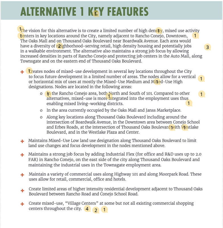 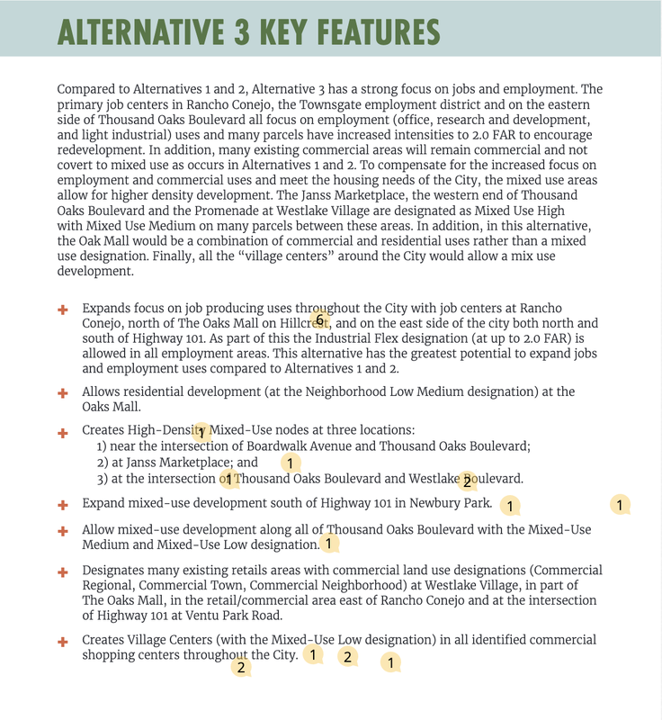 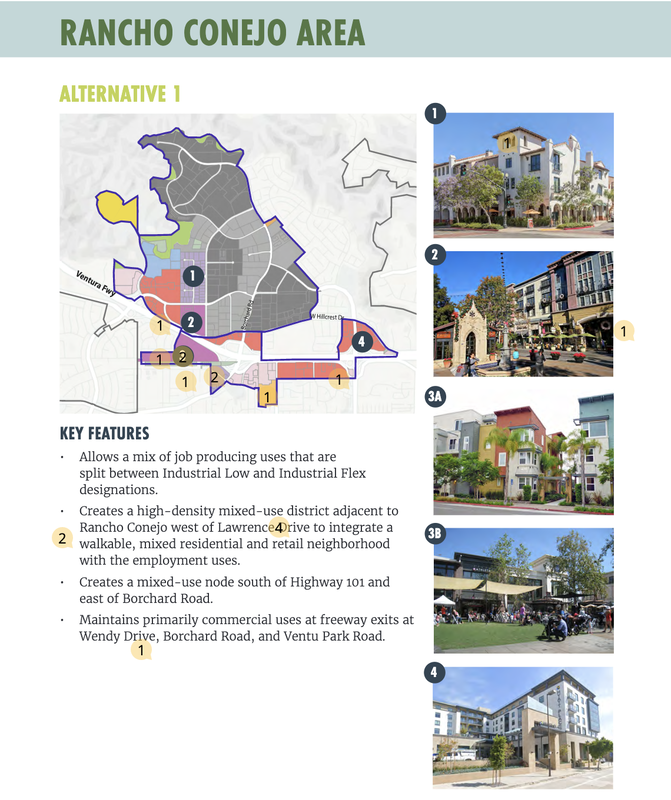 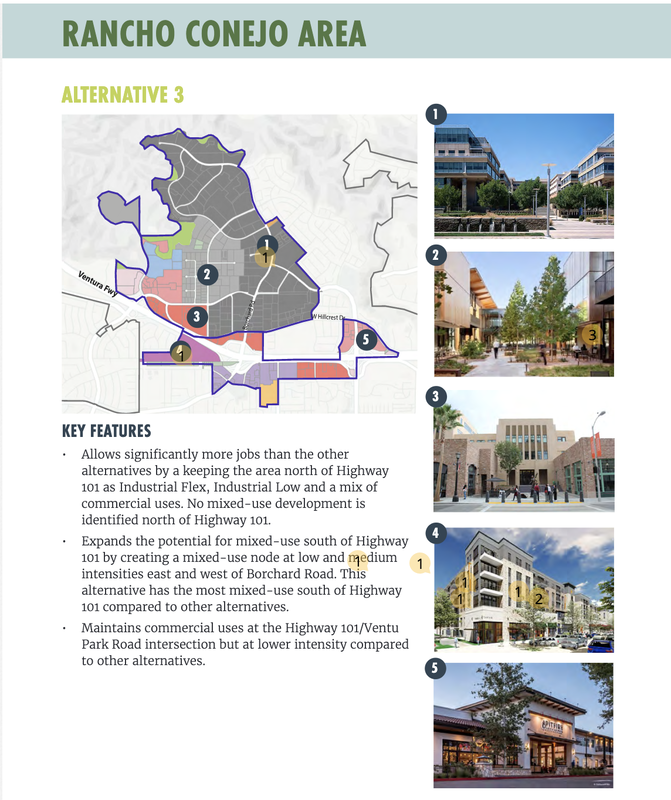 Some other quick takeaways from the survey responses: 1. Rancho Conejo Area (73%) and Downtown and T.O. Blvd Area (77%) percentages related to survey takers who indicated housing and mixed-use should be added to these areas. 2. 70% in favor of increasing density from 30 to 45 units per acre for multifamily residential developments (which paves path for addition of more affordable units) 3. 43% supported creating a mixed-use neighborhood on land currently designated as industrial versus 38% who responded to keep it strictly industrial. 4. 74% strongly agreed or agreed to this statement: The General Plan should allow mixed use development of up to 4 stories and 45 units per acre in Rancho Conejo if it reduces the amount of housing that is needed elsewhere in the City. 5. 70% also supported this selection for Rancho Conejo: An even balance between Industrial Low and Industrial Flex (Alt 1). This has fewer overall jobs and more jobs that are in the light manufacturing and distribution sectors. 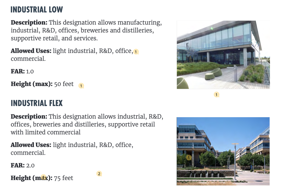 The Greater Conejo Valley Chamber of Commerce also weighed in on its support for mixed-use development in the Rancho Conejo area.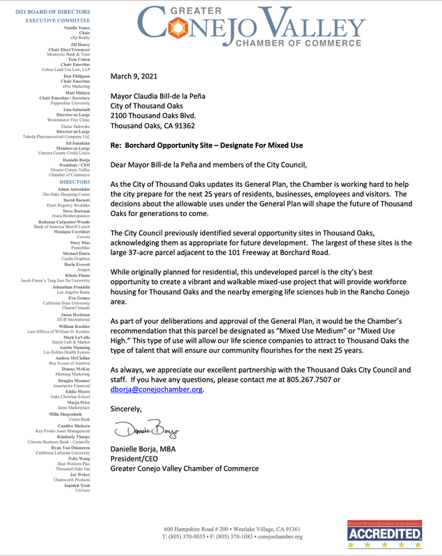 What is Mixed-Use Medium?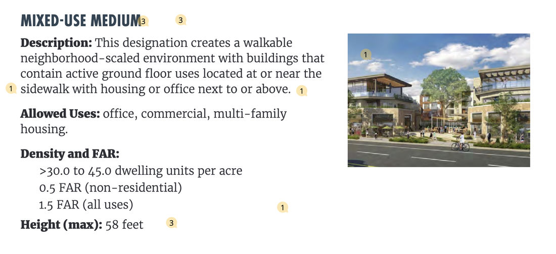 So, after compiling all of the survey results, the city's consultants prepared a new alternative map to review. 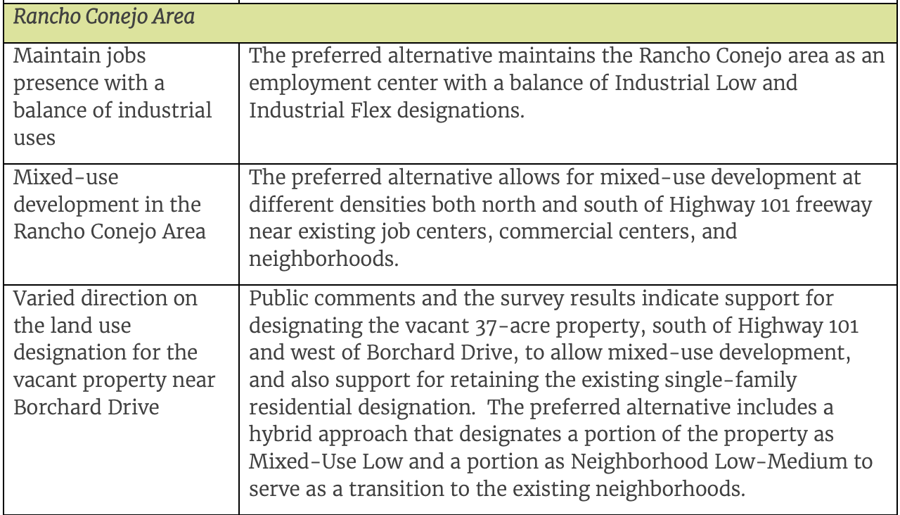 Now ... here's the issue with the the proposed options in the NEW SURVEY, which looks like the screenshot below if you haven't taken the survey yet: 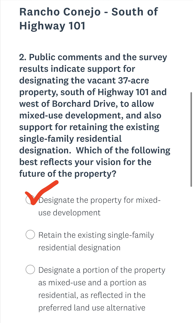 First up ... Bubble #1: "Designate the property for mixed-use development"
... great - this is MY choice and will be my choice when I select it ... but it's not specific ... designate for low, medium or high mixed-use development is a pretty important detail, don't you think? At best this need to be zoned for either medium or high. Why are we leaving this detail out? Bubble #2 "Retain existing single-family residential designation" ... the survey conclusion states that there's support to keep as single-family residential designation, but neither Map #1 or #3 key features (which were voted for by survey takers really backs this). Bubble #3 "Designate a portion of the property as mixed-use and a portion as residential, as reflected in the preferred land use alternative." -- WHY? The new land alternative is creating this "split" option which would be a mix of low-density housing combined with low-density mixed use .... this is not what the survey results indicated survey takers favored. Why are we talking about low-density split options here? This area has MAJOR POTENTIAL to be a huge sales tax revenue generator for our city. The developer (Moradian ... not an "out-of-towner" but one of our neighbors ... someone who has grown up here, lives here and values this city) has plans to turn this 37-acre property (which it can be argued has incorrectly been characterized as "wetlands" despite not meeting criteria for that designation based on a letter from the United States Army Corps of Engineers which states that the parcel does not qualify as a wetland under the corps’ definition) to create a REAL community on this property. A combination of shops, wellness centers/gyms, outdoor picnic/concert/entertainment area, beer gardens, restaurants, inclusion of low-income and affordable housing units, parks and walk trails that connect, a trolley system, etc. Talk about revitalizing and reinvigorating and bringing much needed housing and entertainment to our neck of the woods. Talk about fostering community. That's what smart development can look like. ****** NOW, 805Resistance also caught wind of this, and some other takeaways from the new proposed alternative map, writing: "There is confusion about the general plan and it is frustrating that the areas that have most potential for building affordable housing such as Rancho Conejo project, Kmart and Pumpkin Patch are given low density while the people who have already developed the Promenade and The Oaks were given High Density for mixed use which means they will profit most from doing least. In fact- they do not have to build any housing and can just build their shopping centers up. In addition, the Rancho Project was singled out as a specific project while so many other lots were lumped together (AM note: which many may not realize happened in this latest round). This feels suspicious. The fear is that Rancho is being used as a scapegoat to give people one area to reject while the other developers slide into permission. Review the survey and on question 2 support the Rancho Project for mixed use, which has the potential for a fresh build that is promised to include affordable housing and neighborhood enrichment." **** Anyway, just wanted to share my thoughts before you take the NEW SURVEY. ACTION ITEMS: 1) Take the survey above ... you can review the proposed map and reasoning HERE. 2) If this is important to you, and I hope it is, please attend the GPAC community workshop meeting on Wednesday, April 21, from 6-8 p.m. You can register to attend the virtual workshop, HERE. 3) TO Planning Commission will consider recommendation of the General Plan preferred land use alternative to the City Council at their next meeting on 4/26 at 6 p.m. Submit written comments by email to [email protected] or to speak at the meeting by no later than 10:00 a.m. on 4/26.
0 Comments
Leave a Reply. |
Anonymous MommyArchives
July 2023
Categories
All
|
 RSS Feed